 |
Transportation for Rochefort, France | |
| To reach Rochefort by public transportation you may have to travel via La Rochelle... | ||
|
|
|
Rochefort is on the Charente River near France's Atlantic coast (map), 32 km (20 miles) southeast of La Rochelle, 469 km (291 miles) southwest of Paris and 163 km (101 miles) north of Bordeaux. Because of its links to the nearby seaside resorts, the district is known as Rochefort Océan. The main airport and intercity train station for going to and from Rochefort are in La Rochelle. AirportsThe nearest airport with scheduled service and nonstop international flights is the Aéroport de La Rochelle/ Île-de-Ré (LRH), 41 km (25 miles) northwest of Rochefort in La Rochelle (map), with flights by easyJet, flybe, Hop!, and Ryanair serving Ajaccio, Brussels, Lyon, numerous airports in the UK and Ireland, Portugal and Switzerland. The Aéroport de Rochefort/Charente-Maritime (RCO; formerly the Aéroport de Rochefort - Saint-Agnant), 14 km (9 miles) south of Rochefort (map), is for military and general aviation. TrainsThe Gare de Rochefort SNCF in the city center (map) serves national and regional trains, but not the fast TGV trains. For those you must use the Gare de La Rochelle or Gare de Niort, north of Rochefort or the Gare de Surgères, 27 km (17 miles) northeast of Rochefort (map), from which shuttle buses take you to Rochefort. TGV trains cover the distance between Paris and La Rochelle in about 3.5 hours; from Bordeaux in 2.5 hours. BusLes Mouettes is the Keolis-operated regional bus network linking La Rochelle, Île-de-Ré, Rochefort, Île d'Oléron, Saintes, Surgères and other towns in the Charente-Maritime region. More... Local public transport in the Rochefort Océan region is provided by R'bus. Here's a map of the bus routes.
|
|
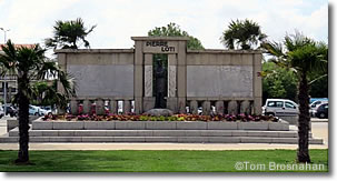
Pierre Loti Monument in the center of Rochefort...
|

